
October 3, 2021
The Department of Environment and Natural Resources (DENR) has entered into a partnership with The German Federal Ministry for Economic Cooperation and Development towards achieving the sixth of the 10 Socio-Economic Agenda that ensures security of land tenure, encourage investments, and address bottlenecks in land titling.
This DENR project is also part of the “Ambisyon Natin 2040.” It is a 25-year visioning led by the National Economic Development Authority that seeks Filipinos’ enjoyment of a“strongly rooted, comfortable, and secure life.”
The sixth of the 10 Socio-Economic Agenda states that government’s aim is to “ensure security of land tenure to encourage investments and address bottlenecks in land management and titling.”
The project titled “Responsible Land Governance in Mindanao” aims to orient local governments and communities including indigenous cultural communities in Misamis Oriental (Region 10), Davao del Sur (Region 11), and Agusan del Sur (Region 13-CARAGA) on management of public lands.
The effective management of lands is believed to have ripple effect– benefitting the economy as government taxation process also becomes effective.
Moreover, investors needing land may find it easier to invest with better land identification and titling processes.

The vision takes into consideration sustainability and conflict sensitivity among ethnic groups and indigenous people on effective land management.
To date, a study on the Land Sector Development Framework (LSDF) was conducted.
It is a 10-year roadmap for the land sector for effective administration that will usher Philippines to economic development.
“This shall provide direction towards the achievement of a highly efficient and effective land sector whose potential is so great to contribute in the economic growth of our country,” according to the Land Management Bureau.
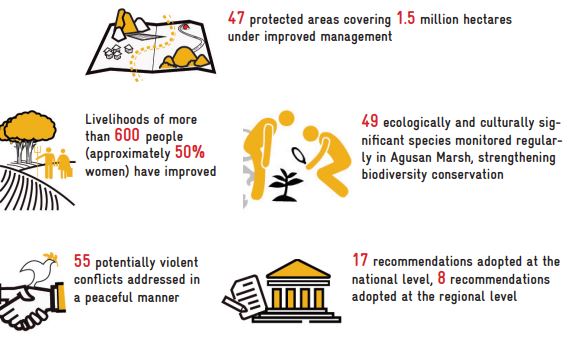
The project also aims to support mitigation of conflicts within selected areas in Mindanao.
A study on the operations of the DAR-DENR-LRA-NCIP Joint Administrative Order No. 1 in Regions 10 and 13-CARAGA was conducted to determine if joint committees are functioning on the ground.
The JAO (Joint Administrative Order) clarifies and restates the functions of each land titling agency.
It provides guidelines in resolving land conflicts in both the national and regional level.
Functions of these various land agencies used to overlap with each other, creating conflict or confusion. The JAO resolves this problem even as there are instances when various land uses conflict with each other. For instance, mining areas may overlap within ancestral domain or Indigenous People’s lands.

. DAR stands for Department of Agrarian Reform, LRA for the Land Registration Authority, and the NCIP for National Commission on Indigenous Peoples.
Laws and policies also serve as an enabling environment for responsible land administration and management.
RLGM initiated studies to clarify the definition of terms and frequently asked questions for lands, and review land-related laws and policies on tenure.
Partner agencies and local government units were re-oriented on national policies such as the enhanced Comprehensive Land Use Plan (CLUP) guidelines. GIS (Geographic Information Service) application for land titling is also being explored.
The project also offered capacity building activities to LGUs in using Unmanned Arial Vehicles (UAV) for land use planning.
Future activities are being eyed as potential activities for the project.
The DENR is proposing a review of alternative dispute resolution mechanisms and a unified map to identify existing tenurial (land titling) instruments.
The unified map would make it easier for national and local government units to access data to carry out their own mandates. (Melody Mendoza Aguiba)
